ABOUT THE PROJECT
The program- “Climate Services for Resilient Agriculture in India” represents a unique partnership between USAID and Skymet Weather Services Private Limited. Skymet in partnership with USAID aims to help Indian farmers in mitigating agricultural risk due to climate change. This project aims at providing the farmer a holistic solution for risk cover at all the levels of crop life cycle, thereby increasing farmer’s adaptive capacity to climate associated risks.
The program will be implemented in nine states across 31 districts in India, and will provide farmers with a holistic solution for risk coverage at all the levels of crop life cycle, thereby increasing farmer’s adaptive capacity to climate associated risks and vulnerabilities.
This will make existing climate data and information, risk mitigation tools, and services more accessible to farmers in target states in India; and commit to development of new risk mitigation products to support decision-making targeted at the needs of specific climate-vulnerable communities.
PROJECT OBJECTIVES
- Increasing farmer’s access to high quality and location specific weather and climate information across nine states in India
- Deploy an ICT-based location specific crop advisory and farming practices package across the nine states and 31 districts in India, based on high quality weather data
- Provide farmers access to a comprehensive weather based crop insurance model for mitigating risks associated with climate variability
- Develop a community of practice on climate services in India for sharing best practices and lessons learnt
PROJECT INTERVENTION
STATE-WISE FARMER
Since, the beginning of project till the third quarter of four year of the project (i.e. during 1st October 2015 to 30 June 2019), 80,423 farmers have been registered under the project. The state-wise registration of farmers is reflected in the table below:
| State
|
Total Farmer Registered
|
| Andhra Pradesh
|
5835
|
| Bihar
|
10824
|
| Gujarat
|
10803
|
| Haryana
|
8269
|
| Madhya Pradesh
|
13856
|
| Odisha
|
7822
|
| Punjab
|
7660
|
| Rajasthan
|
13237
|
| Telangana
|
5834
|
| Total
|
85166
|
Till 30 June 2020
GEO TAGGING OF FARMS
Each of the Registered farmer under this project is geo-tagged. Skymet has developed mobile application known as ‘Skygreen’, which was introduced for farmer’s registration and activity monitoring on the field, The app also capture the farmers geo-coordinates, which helps in service customization and better service delivery.
SKY-MITRA APP
Skymitra is an android mobile App developed by Skymet Weather under this program to help the farmers by providing relevant weather and agro advisory information quickly. Updating 7 days and 15 days weather forecast on “Skymitra” App.
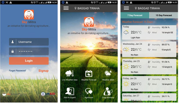
Accurate weather forecast not only helps farmers to protect themselves against the natural factors, but they can also get benefitted significantly as long as they are aware of the actions they can take to leverage good weather patterns.
Under the project intervention, Skymet gives access to regular and reliable weather information to all the small, medium and marginal farmers in all 31 geographies under the project. Shorter real-time meteorological information such as daily forecast further helps to determine timing of various activities such as sowing, weeding, spraying, and harvesting.
Real-time daily weather data, 7 days forecast, and 15 days forecast are helping farmers make very practical decisions that can save their time and money or protect them from weather related damages.
STRATEGIC PARTNERSHIPS WITH US AGENCIES
Skymet has entered into several strategic partnerships with American public and private sector institutions to develop weather forecast and agricultural advisories for Indian farmers.
National Oceanographic and Atmospheric Administration (NOAA):
Satellite data is analyzed and processed by meteorologists in Skymet by using a combination of NOAA datasets that is generated through the National Oceanographic and Atmospheric Administration operated satellite (NOAA operates under the U.S. Department of Commerce) and publicly available information provided by the Indian Meteorological Department to develop algorithms for site specific weather forecasts. Data from these satellites is crucial for numerical weather prediction (NWP) to harness the power of computers to run algorithms that process massive amounts of satellite data. Once this information is generated, the AWS data is ingested into dynamical model input which has global data, then model is run to get better forecast instead of using simple global data.
University Corporation of Atmospheric Research (UCAR):
Skymet partnered with the weather giant UCAR to enhance weather accuracy across the country. The partnership between two leading companies is expected to provide more detailed tropical weather patterns, including monsoons, with greater precision and accuracy. This agreement will empower Skymet Weather to use a customized version of the DICast® system, cutting edge automated weather prediction technology developed at the National Center for Atmospheric Research (NCAR). DIcast uses advanced statistical techniques to blend output from different weather models with observations and statistical datasets, generating dynamically tuned predictions for specific sites that are more accurate than those based on a single model and traditional statistical approaches.
DAVIS:
In this project, Skymet has installed its 675 “Automated Weather Stations” (AWS) to generate real-time granular weather and crop monitoring data. The automated data generated by the AWS is highly reliable and can be used to extrapolate weather parameters in near term. An AWS typically consists of a weather-proof enclosure containing the data logger, rechargeable battery, telemetry (optional) and the meteorological sensors. Skymet procures the sensors from Davis (an American company) and integrates this with other parts of the AWS procured from local manufacturers.
More...
BENEFITS TO FARMERS AND STAKEHOLDERS
- Accurate and timely availability of weather information
- Increase in capacity to handle climate risk in agriculture
- Better resource utilization based on real time crop advisories
- Securing farm incomes from adverse climate conditions