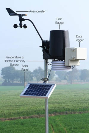
 Automated Weather Stations (AWS) generates real-time granular weather and crop monitoring data. Under the PCSRA project, Skymet has installed 675 AWS across the 9 target states. AWS is a comprehensive device that captures real-time weather parameters such as temperature, rainfall, wind, and humidity at a specific location. The automated data generated by the AWS is highly reliable and can be used to extrapolate weather parameters in near term. An AWS typically consists of a weather-proof enclosure containing the data logger, rechargeable battery, telemetry (optional) and the meteorological sensors.
Installation of AWS is based on GIS analysis if the terrain is flat then one AWS can cover range between 10-12 kms. If terrain is undulated, then one AWS can cover 5-7 kms. Forest cover can also affect the range of AWS coverage. In case of forest, one AWS can cover only 5-7 kms. If AWS machine is installed in high elevation zone, then it can cover only 5-6 kms of area. As per revised guidelines by committee on setting up AWS (Automatic Weather Station) & ARG (Automatic Rain Gauge) by private agencies and their accreditation, standardization, validation and quality management data 2015, AWS’s have been put on ground. So, all 675 Automatic weather stations across 31 districts of 9 states have been grounded.
AWSs are now been upgraded by attaching Cameras and Crop Sensors to it. This will help the stakeholders, primarily the farmers, to monitor the big farms efficiently as well as gear them up in advance to combat the crop damages by any of the fators incluidng weather, pests and disease. This would help in impleting the idea of precision agriculture. The crop sensors is the combination of follwing sensors:
Dielectric Leaf Wetness Sensor: Dielectric Leaf Wetness Sensor enables accurate and affordable leaf wetness monitoring. The Leaf Wetness Sensor determines the presence and duration of wetness on a leaf’s surface, enabling researchers and producers to forecast disease and protect plant canopies.
Solar Radiation Sensor: Solar Radiation Sensor measure various aspects of the energy imparted by the Sun on the Earth’s surface.
Soil Moisture Sensor: The Soil Moisture Sensor uses capacitance to measure dielectric permittivity of the surrounding medium. In soil, dielectric permittivity is a function of the water content. The sensor creates a voltage proportional to the dielectric permittivity, and therefore the water content of the soil. The sensor averages the water content over the entire length of the sensor. The Soil Moisture Sensor is used to measure the loss of moisture over time due to evaporation and plant uptake, evaluate optimum soil moisture contents for various species of plants, monitor soil moisture content to control irrigation in greenhouses and enhance bottle biology experiments.
To generate the weather information, Satellite data is analyzed and processed by meteorologists in Skymet by using a combination of NOAA datasets and publicly available information provided by the Indian Meteorological Department to develop algorithms for site specific weather forecasts. Data from these satellites is crucial for numerical weather prediction (NWP) to harness the power of computers to run algorithms that process massive amounts of satellite data.
Once this information is generated, the AWS data is ingested into dynamical model input which has global data, then model is run to get better forecast instead of using simple global data. This is also called data assimilation. Weather forecast and ago-advisories are disseminated to registered farmers by tracking their GIS location through a SMS in text-lite format, which can be received by any basic mobile phone.
All 675 Automatic Weather Stations installed under this project are a combination of Indian and U.S. technology, with sensors imported from a California-based company called Davis Instruments and other components assembled in India. This year, Skymet collaborated with another American institution, UCAR to strengthen weather forecasts be it short range, medium range, long range, inclement weather alerts, heatwaves and hailstorms.
“Skymitra” is an android based mobile application developed by Skymet under this program in order to help farmers by providing relevant weather and agro advisory information quickly.
Mitra means friend and we have created a farmer centric application. With the click of a button, they can get the information on weather for the current day which is updated on hourly basis (live weather information), weather forecast of next 7 days, 15 days, and agro advisories based on real time live weather.
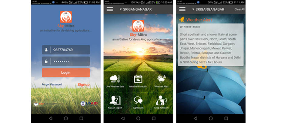
Features like extreme weather alerts, live weather data of nearest AWS and Agri forum a unique platform where farmers can share their experience and ask questions to agriculture experts.
Other farmers can also see updates of other farmers of that particular district. The App is multilingual in seven languages named English, Hindi, Gujarati, Punjabi, Oriya, Telugu and Kannada targeting rural farmers.
The App is useful for farmers or anyone related to the agriculture. This App automatically captures the location of farmers using mobile GPS and fetch the weather data from server which falls within the range of 10 km -15 km.
When farmers login into the page, he could see his form, along with the live AWS data that is attached to his respective field. All his details are listed along with his farm wise crop calendar.
Farmers are provided with disease alerts and advisories in local languages according to weather events and their correlation with the sowing date of his crop. Farmer can see forecast for his farm by asking an expert and also participate in Agri forum that is present in the App. Below is a list of features available to the farmers in the Skymitra App
- Farmer details
- Live Weather data
- Weather Forecast - 7days and 15 days ahead
- Weather Alerts
- Crop Advisories
- Agri Forum
- Ask an Expert
- Language Support
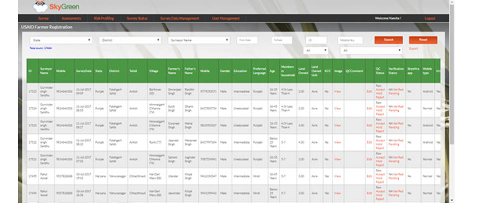
Skymet has developed an android based App named “Skygreen” for making the process of farmer registration and data collection on real time basis. District in-charges fill the farmer questionnaire via Skygreen, Android App and the same information can be shared with the central team within 24 hours.
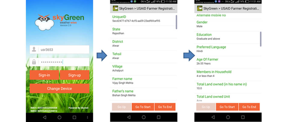
Skymet has developed an online data monitoring tool named “Skygreen” to monitor the data of registered farmers under the program. In which continuous upgradations are going on to make it more user friendly.
Through “Skygreen”, one can see the farmer information captured during the registration process, where Skymet district in-charge fills the farmer questionnaire via Skygreen android App and the same information is reflected on the portal within 24 hours. Skygreen portal is password protected to keep the data secure.